Skip to main content
Go to side pane
PieFed
Home
Home
Popular
All posts
Topics
Browse by topic
All communities
Log in
Register
Donate
Home
Topics
Thoughtful Stuff
Map Enthusiasts@sopuli.xyz
Map Enthusiasts
Create post
Hot
Top
New
Active
List
Tile
Wide tile
110
2
EU states signing declaration committing to legal equality, protection, national strategies and work for social acceptance of LGBTIQ people
by
Microw
2024-05-18T12:58:03Z
19
104
7
Life expectancy in 1800, 1950 and 2015
by
Blaze
2024-05-11T10:56:28Z
14
56
2
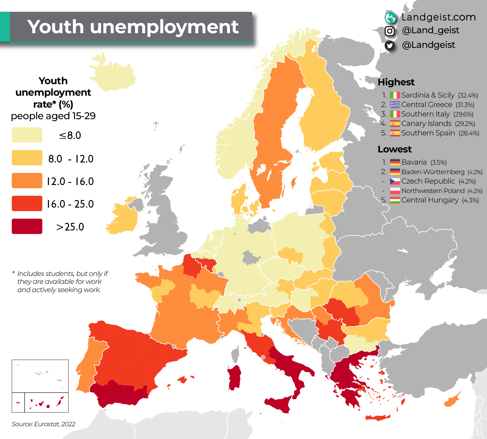
Youth unemployment in Europe
by
garfaagel
2024-05-09T14:09:27Z
5
75
1
Inherent Land Quality Assessment - U.S. department of Agriculture
by
Blaze
2024-05-09T08:28:39Z
10
51
2
Mother's Day around the world (for people in Spain and Portugal, it's today)
by
Blaze
2024-05-05T12:10:34Z
2
39
1
Viceroyalty of New Spain, c. 1800
by
Blaze
2024-05-04T12:50:26Z
3
46
0
1849 map of Scotland [6598 x 8922]
by
Blaze
2024-05-02T16:27:11Z
0
113
8
Earthquake Risk
by
witchdoctor
2024-05-01T18:16:09Z
11
12
3
l’Impero Italiano
by
lars
2024-05-02T00:20:17Z
2
57
1
Butterfly Migration - A bit different from your usual map
by
Blaze
2024-05-01T13:00:56Z
0
111
1
Legality of same sex relationship in Africa
by
witchdoctor
2024-04-30T22:08:24Z
9
93
0
Australian government travel advice (As of April 2024)
by
witchdoctor
2024-04-30T21:21:17Z
26
84
2
Official languages in Central and South America
by
witchdoctor
2024-04-30T18:06:14Z
13
14
1
HDI projection of Brazilian states for 2023-2024
by
witchdoctor
2024-04-30T20:58:02Z
0
87
4
Labour Day on 1st of May
by
Blaze
2024-04-30T13:54:52Z
22
83
7
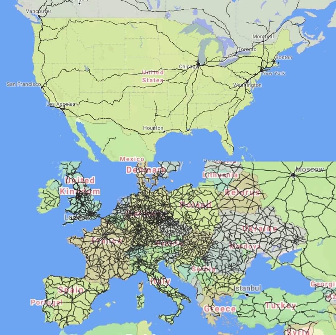
A map of passenger trains in the US vs Europe
by
The Picard Maneuver
2024-04-29T17:22:38Z
13
15
4
H-E-B stores in Mexico
by
witchdoctor
2024-04-28T22:58:51Z
1
49
7
Home ownership in European countries (2022)
by
witchdoctor
2024-04-28T22:31:57Z
3
33
5
Education index
by
witchdoctor
2024-04-28T21:34:48Z
6
39
2
Turkey's 2023 presidential election
by
witchdoctor
2024-04-28T21:32:11Z
4
28
2
Brazil's HDI progress
by
witchdoctor
2024-04-28T21:28:30Z
0
32
5
Main source of electricity in each Brazilian state
by
witchdoctor
2024-04-28T21:22:20Z
3
89
4
GDP per capita progress in South America
by
witchdoctor
2024-04-28T20:50:57Z
35
57
8
Voting on a ceasefire in the Israel-Palestine conflict
by
witchdoctor
2024-04-28T20:44:51Z
3
13
6
Jewish population in Brazil
by
witchdoctor
2024-04-28T21:19:45Z
0
19
4
HIV Incidence rate by Brazilian states
by
witchdoctor
2024-04-28T20:47:25Z
2
17
2
Main commodity by Brazilian states
by
witchdoctor
2024-04-28T20:42:48Z
0
101
1
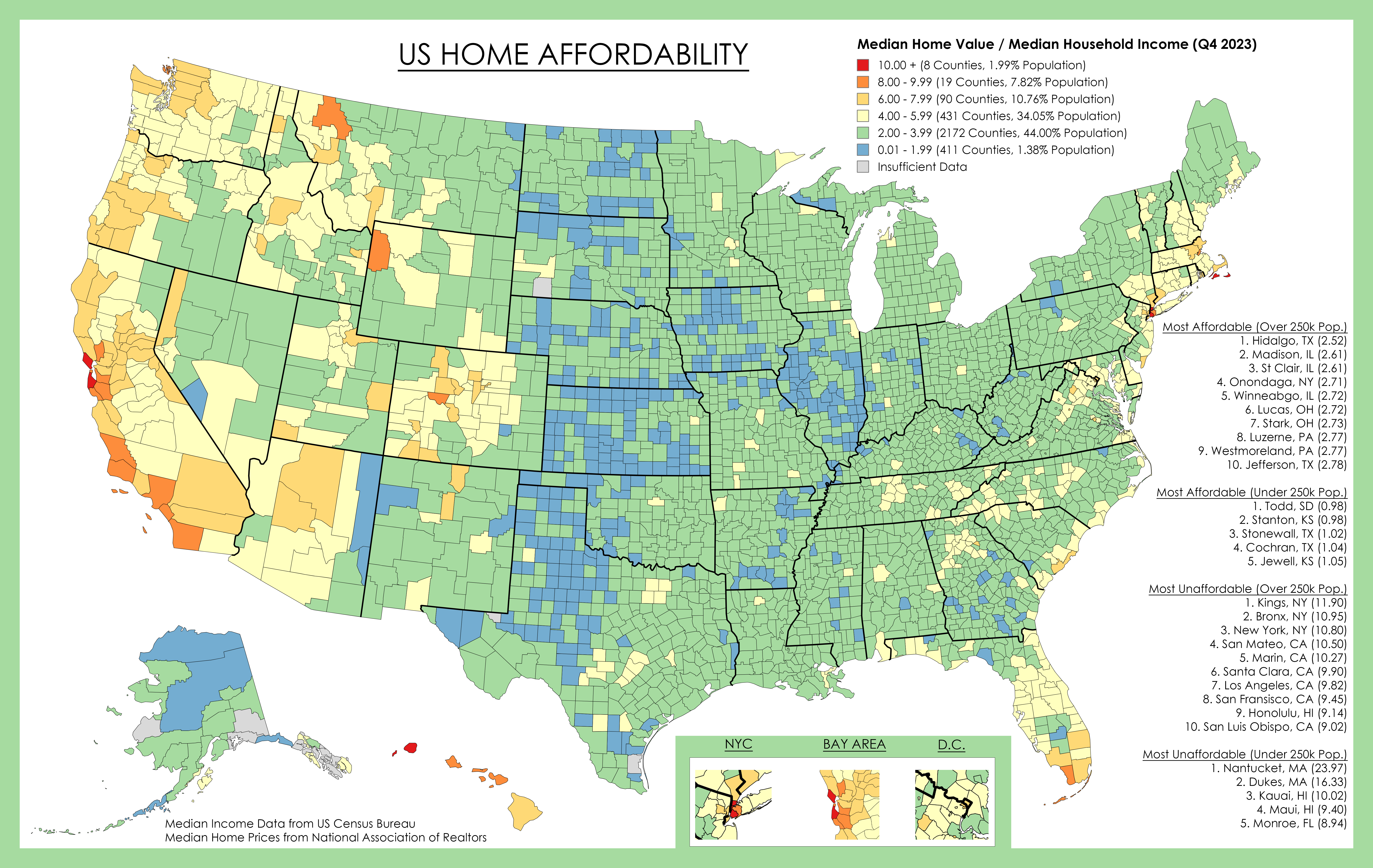
US Home Affordability by County (2023) by TA-MajestyPalm@reddit.com
by
Blaze
2024-04-28T12:55:52Z
17
84
2
Map of density of the United Kingdom
by
Blaze
2024-04-27T21:19:55Z
12
55
2
Overview of the slave trade out of Africa (1500-1900)
by
spiritedpause
2024-04-27T09:00:25Z
6
51
0
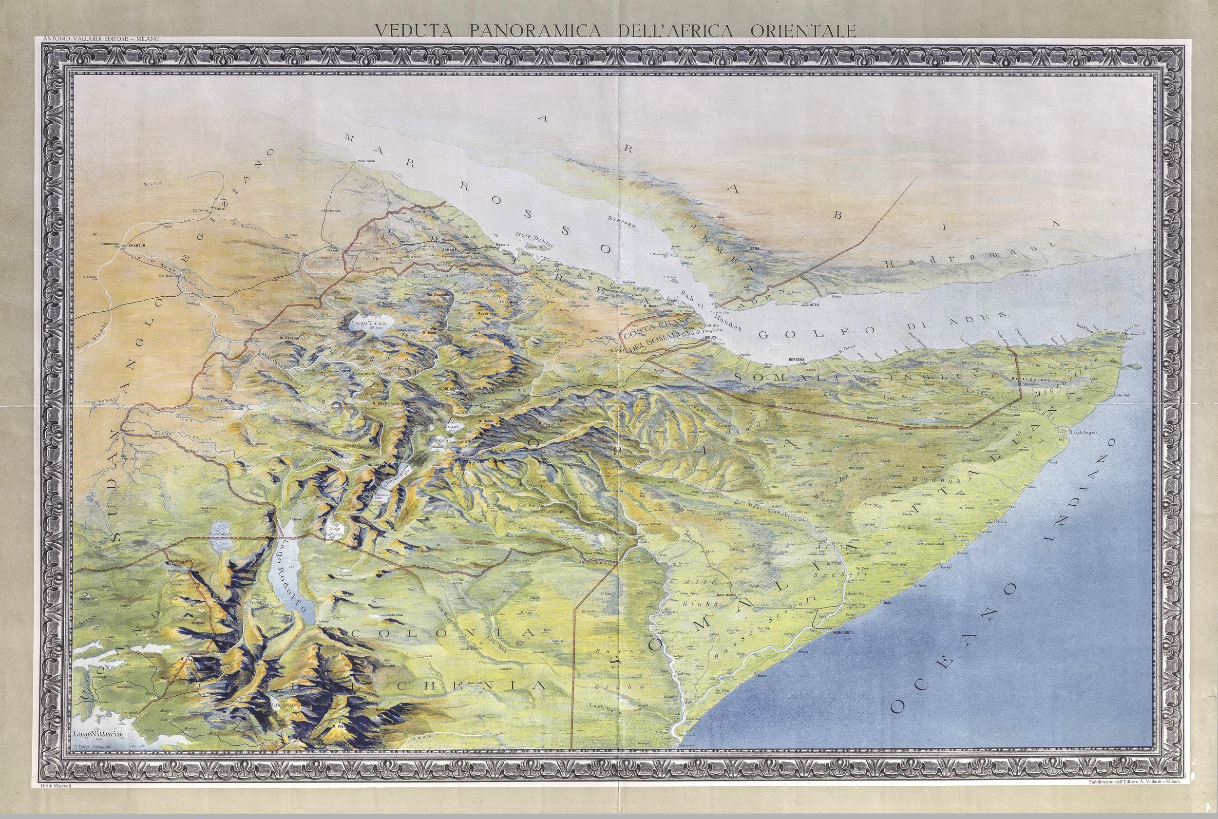
Horn of Africa map
by
Blaze
2024-04-26T17:07:15Z
0
45
0
Every building along the lines are connected via footbridges above ground. You can walk through them without crossing any roads. Sha Tin, Hong Kong
by
Blaze
2024-04-26T17:03:18Z
0
41
0
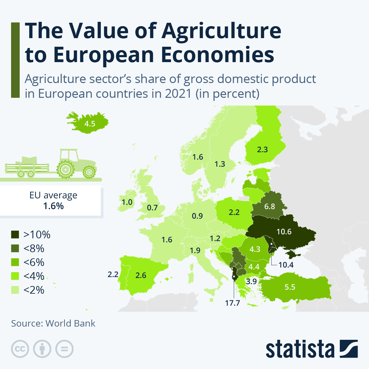
Agriculture sector's share of GDP in European countries
by
garfaagel
2024-04-25T13:04:58Z
5
310
35
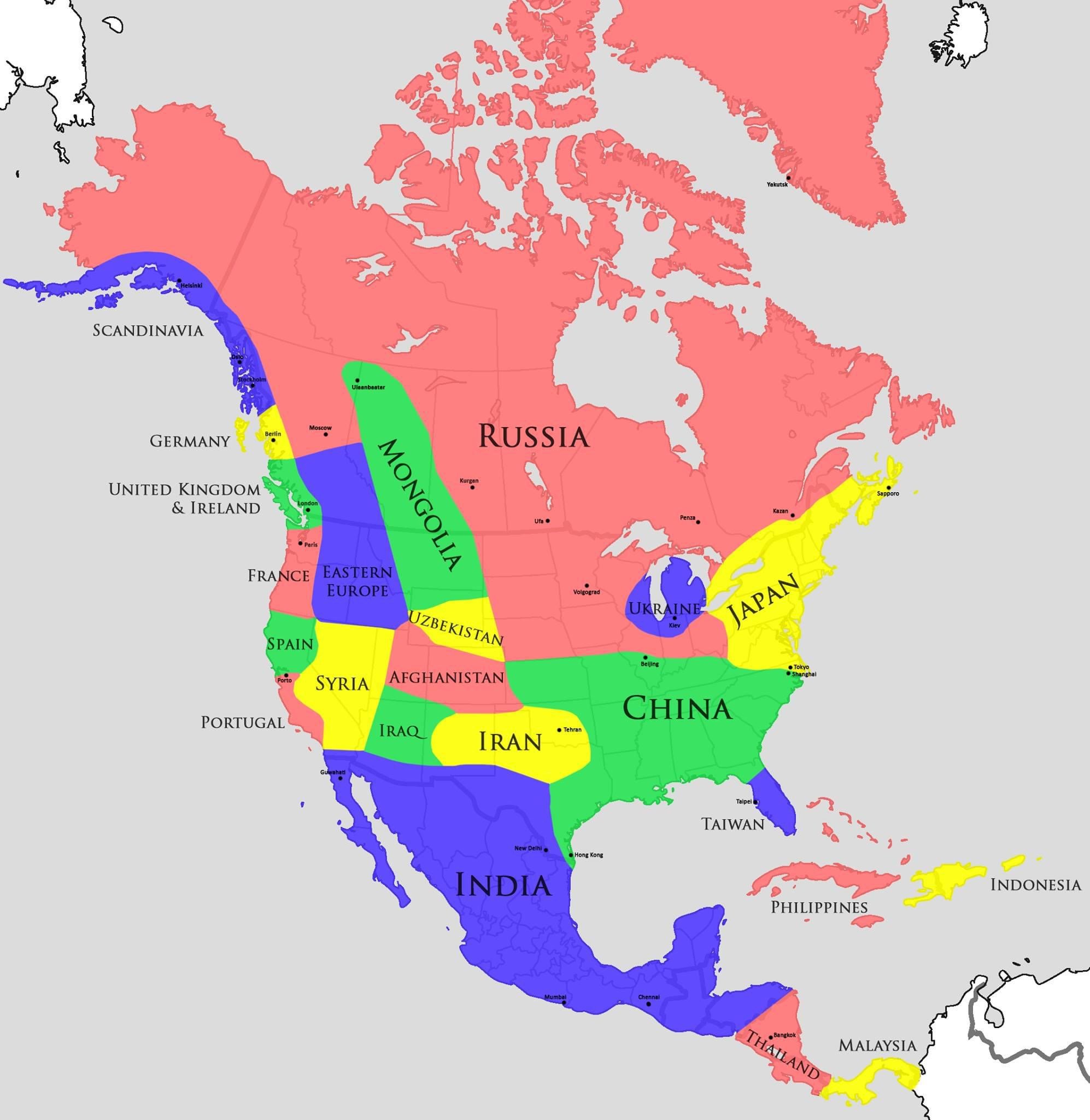
A map of North America using countries with comparable climates
by
The Picard Maneuver
2024-04-18T16:44:59Z
30
226
3
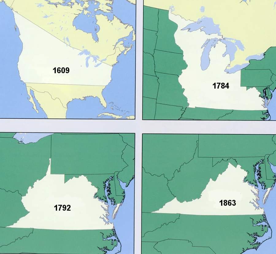
Virginia's land claims by year
by
The Picard Maneuver
2024-04-17T13:43:32Z
10
34
1
Foreign military bases in Djibouti (Google Translate English inside post if you can't figure out the Spanish)
by
garfaagel
2024-04-14T13:28:46Z
0
57
3
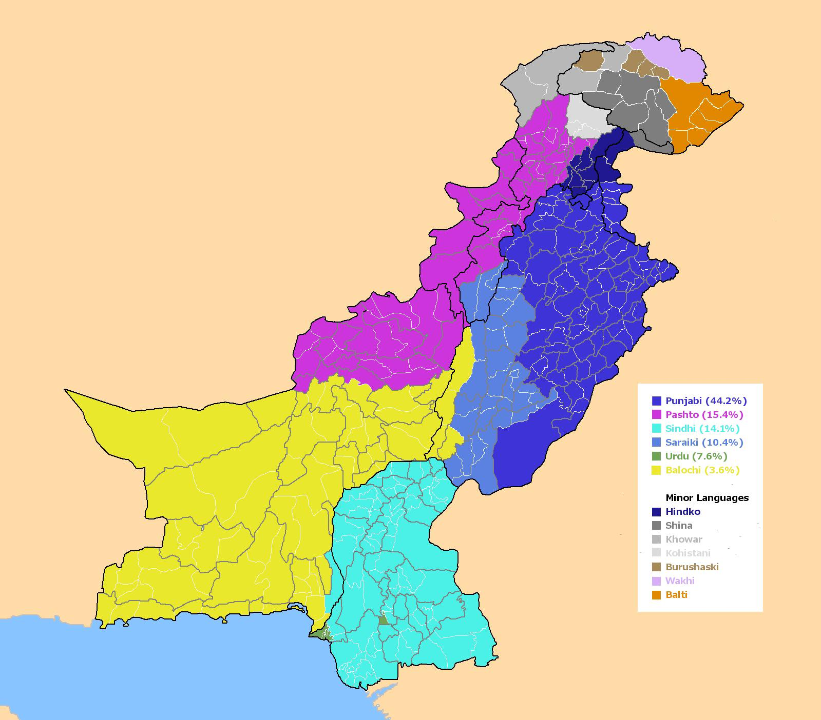
The most natively spoken languages in Pakistan
by
Blaze
2024-04-11T18:29:54Z
6
231
34
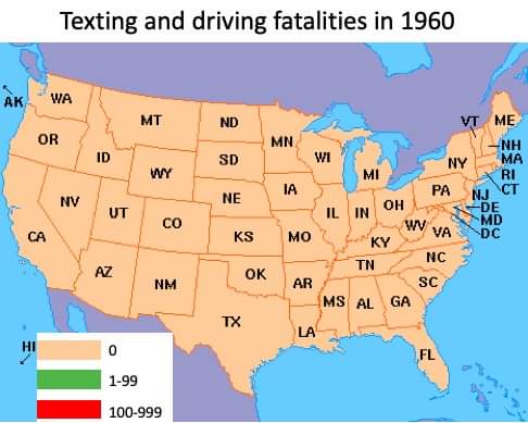
Texting and Driving Fatalities in 1960
by
The Picard Maneuver
2024-04-08T15:42:45Z
16
231
5
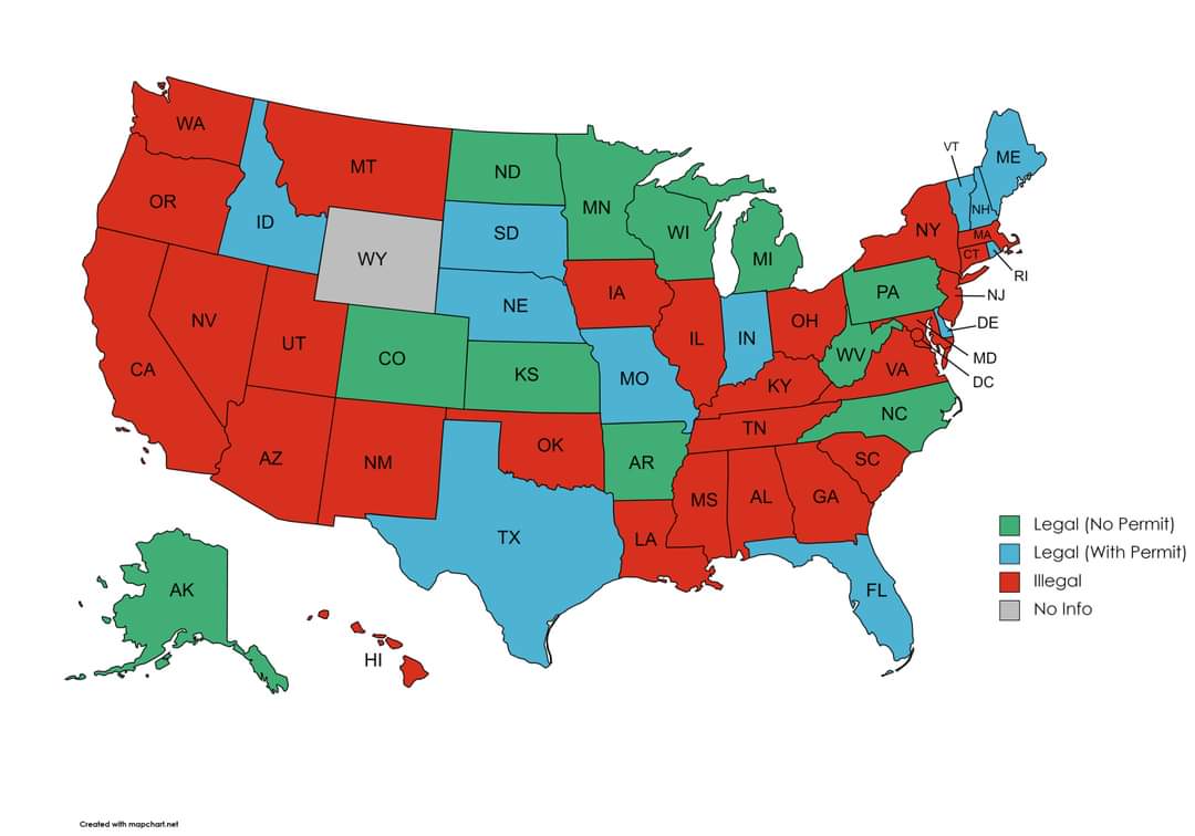
State laws regarding personal ownership of an alligator
by
The Picard Maneuver
2024-04-07T18:20:42Z
23
55
0
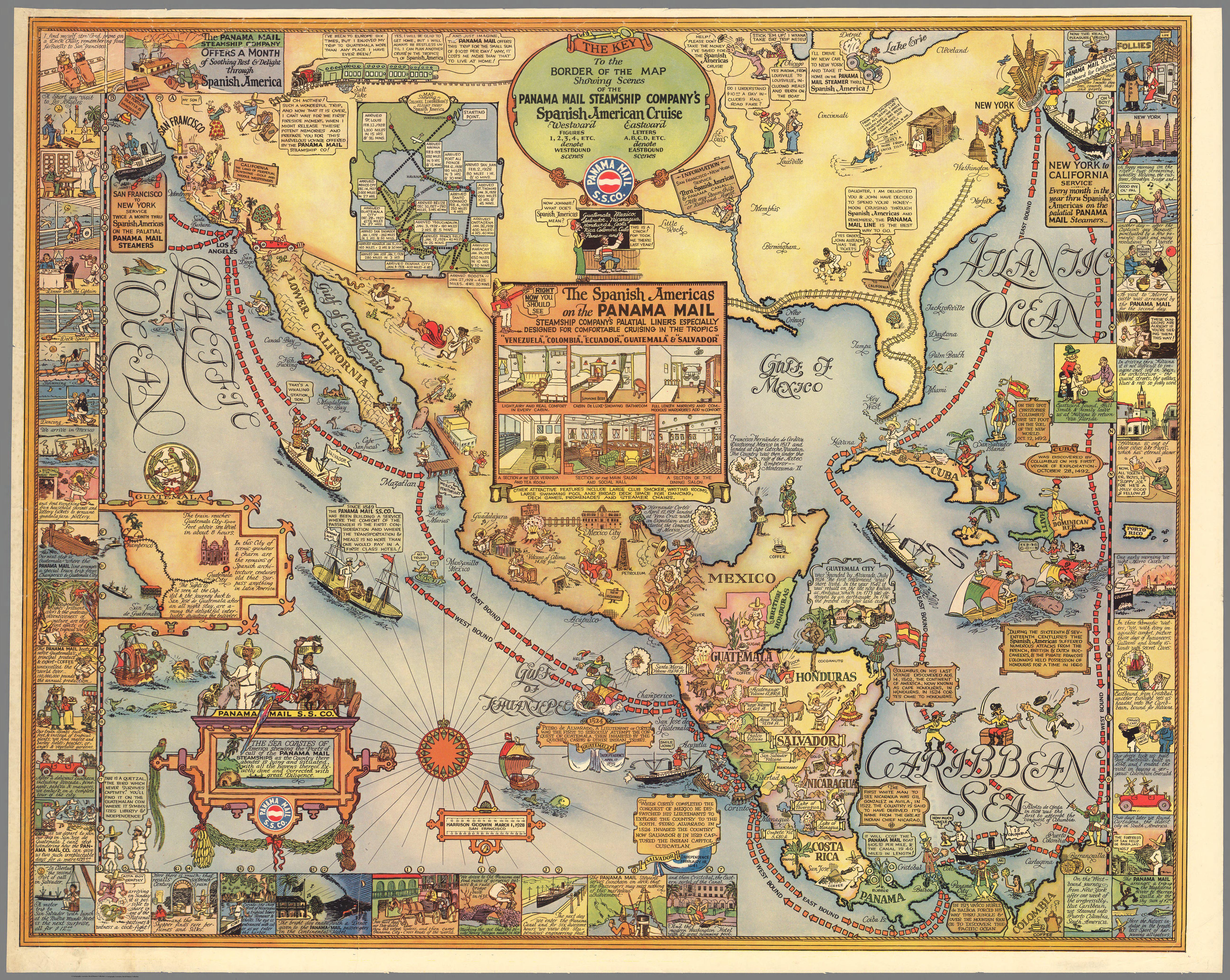
Spanish American Cruise (1928)
by
Blaze
2024-04-07T13:42:44Z
1
109
6
Average Ground Water Temperature in the Contiguous U.S.
by
spiritedpause
2024-04-04T10:49:31Z
18
325
10
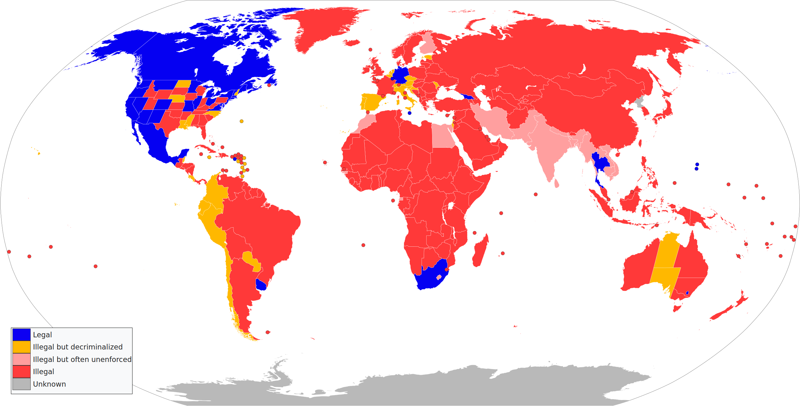
Legal status of cannabis possession for recreational use
by
garfaagel
2024-04-01T10:59:02Z
109
162
7
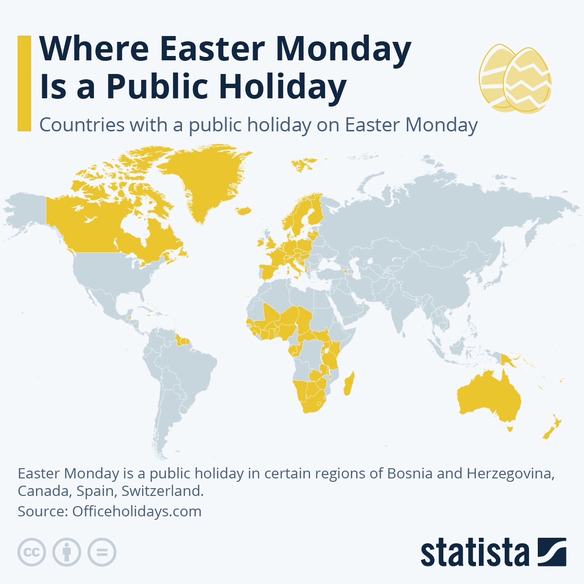
Where Easter Monday Is a Public Holiday
by
garfaagel
2024-04-01T08:18:08Z
19
500
24
The most popular metal band (2024) from each country, according to Spotify
by
Blaze
2024-03-30T12:41:34Z
195
53
0
PM2.5 air pollution in Europe
by
garfaagel
2024-03-28T13:26:10Z
7
223
6
How dogs bark around the world
by
Blaze
2024-03-26T11:26:30Z
38
119
0
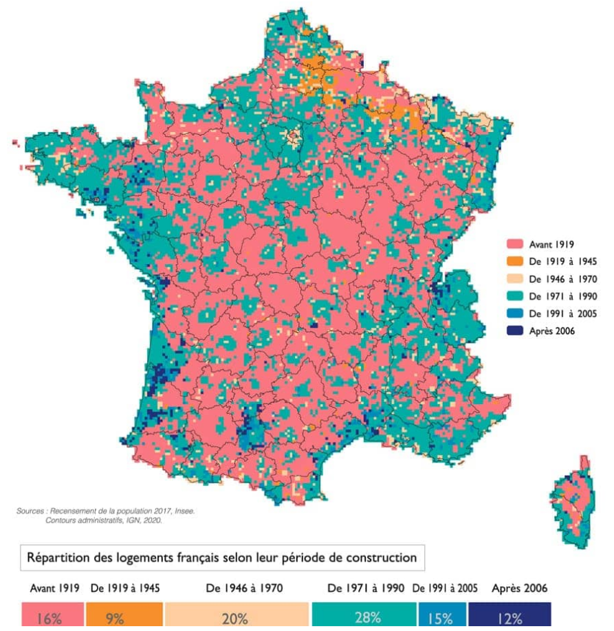
Dominant period of construction of housings in France
by
garfaagel
2024-03-23T12:27:41Z
14
87
2
The World's Population Compared to India
by
Blaze
2024-03-18T17:56:20Z
0
71
2
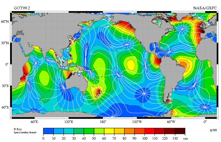
Tidal range around the world of the principal lunar semi-diurnal constituent
by
garfaagel
2024-03-16T14:34:17Z
10
191
7
The real size of Australia
by
Blaze
2024-03-13T19:24:51Z
28
35
2
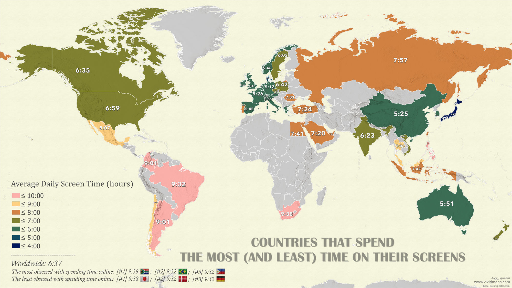
Countries that spend the most (and least) time on their screens
by
garfaagel
2024-03-08T17:23:50Z
6
168
2
Country calling codes
by
Blaze
2024-03-06T15:59:51Z
38
261
12
In addition to clocks moving forward by 60 minutes in many parts of these 48 states next week
by
lars
2024-03-03T22:31:04Z
44
420
2
Population density of Africa
by
Blaze
2024-03-03T10:49:13Z
29
56
2
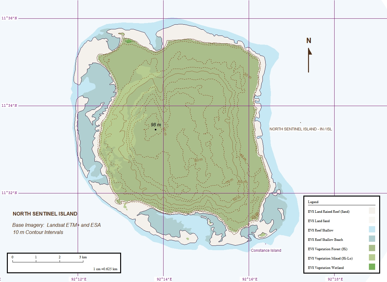
𝘊𝘩𝘪𝘢 𝘥𝘢𝘢𝘒𝘸𝘰𝘬𝘸𝘦𝘺𝘦𝘩, or North Sentinel Island, home of one of Earth’s few other groups of 𝘏𝘰𝘮𝘰 𝘴𝘢𝘱𝘪𝘦𝘯𝘴 (1240×904)
by
lars
2024-03-03T01:37:35Z
6
32
2
Find your address on the pangea
(
endlesstalk.org
)
by
Sphks
2024-02-20T06:38:52Z
2
108
10
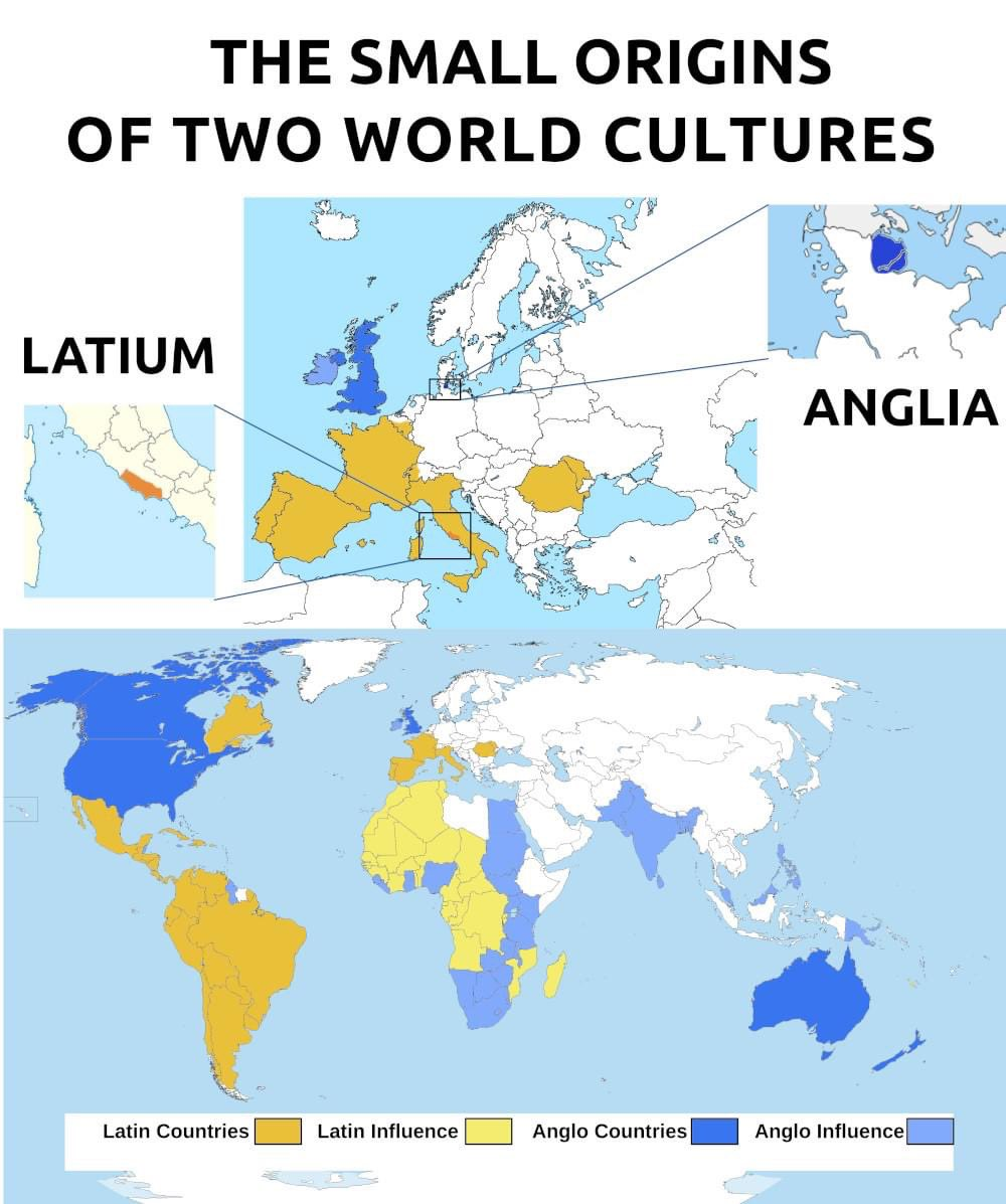
The unlikely progenitors of world empires: Latium and Anglia
by
lars
2024-02-20T02:44:59Z
12
158
7
Some countries whose endonyms are not like their English exonyms
by
lars
2024-02-19T02:36:33Z
32
212
18
All cities more populous than every other city north of them
by
lars
2024-02-10T03:18:08Z
38
125
2
The English words “wheel” and “rickshaw” are extraordinary cognates
by
lars
2024-02-09T00:43:39Z
6
81
0
The Pacific Rim
by
Blaze
2024-02-08T10:32:59Z
2
168
0
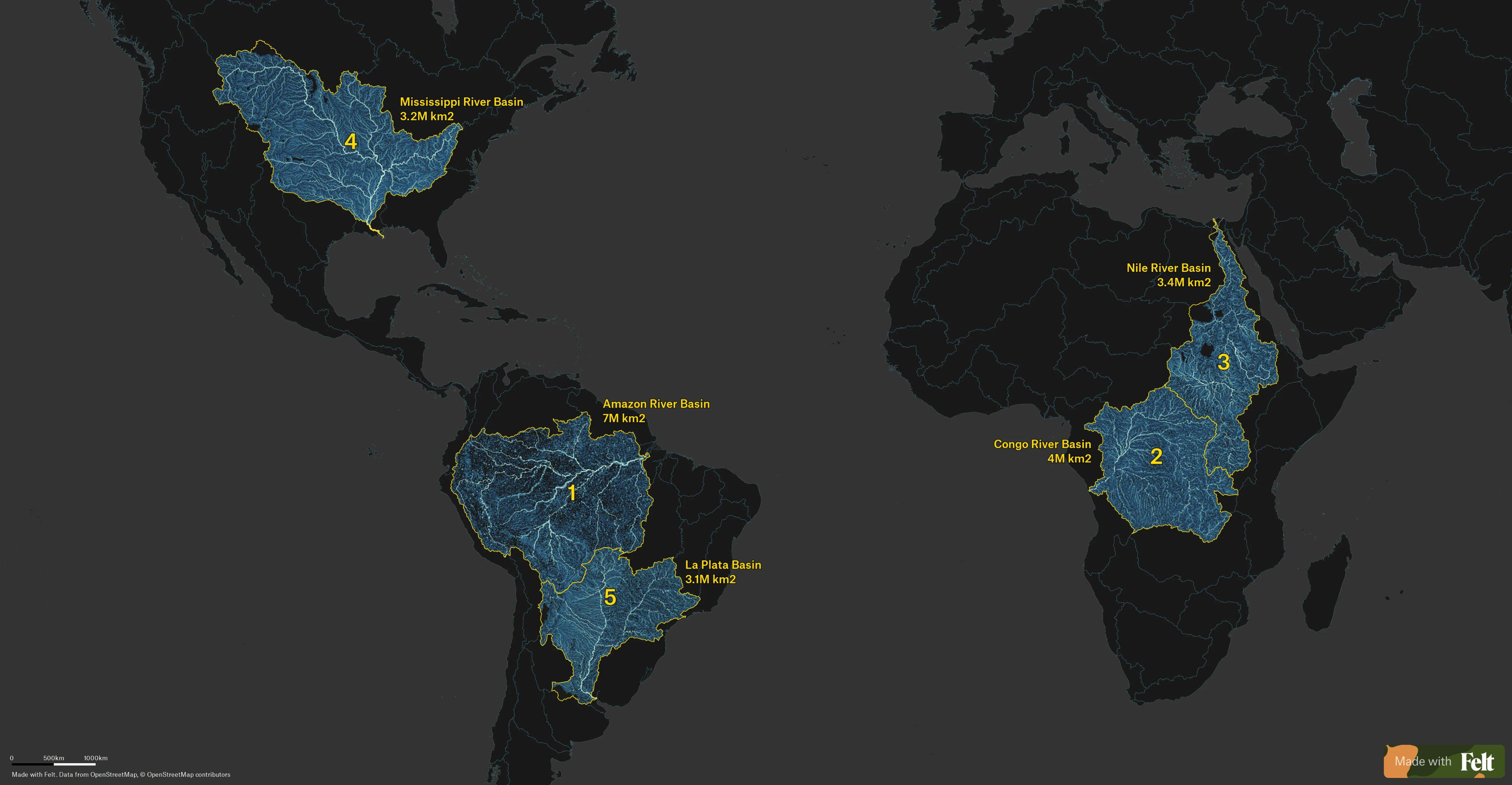
The 5 largest rivers basins
by
Blaze
2024-02-06T11:08:32Z
24
52
0
Map of the Baltic States published in 1948-49. E. Krasauskas
by
Blaze
2024-02-02T11:23:06Z
3
25
2
Turkey and Greece population movement and resettlement
by
JimmyBigSausage
2024-02-02T12:21:55Z
4
24
0
Spain, Portugal, Andorra and Gibraltar - National Geographic (2009)
by
Blaze
2024-01-30T14:51:15Z
1
40
0
Bird Migrations in the Western Hemisphere (National Geographic, 2011)
by
Blaze
2024-01-29T16:38:27Z
1
331
6
Mississippi basin
by
Blaze
2024-01-28T13:02:25Z
31
41
0
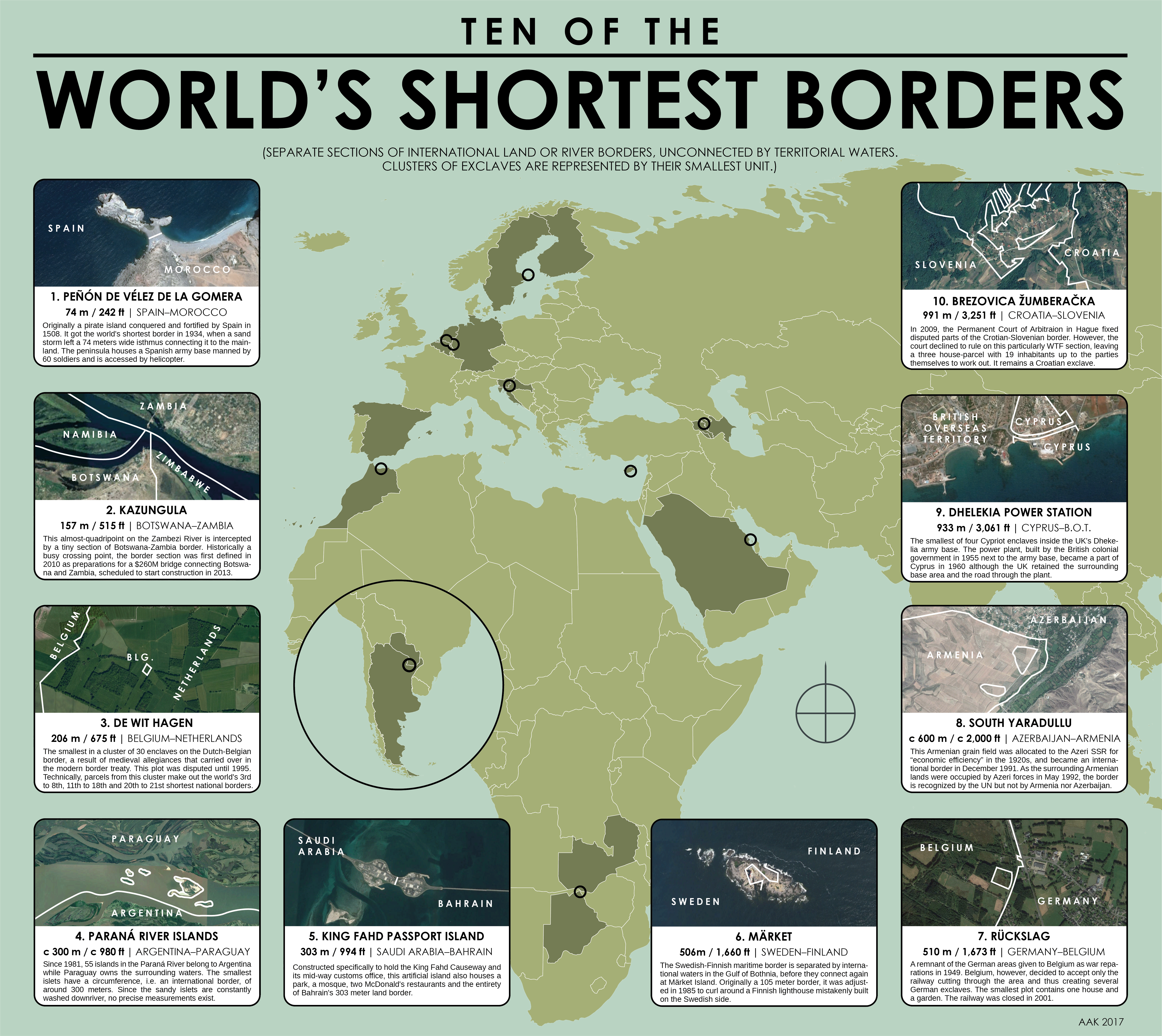
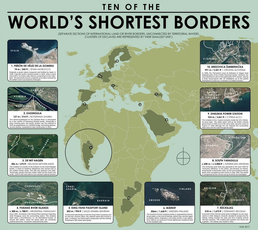
Ten of the World’s Shortest Borders (2017)
by
lars
2024-01-28T05:19:37Z
1
27
1
Map of Scotland, by Perrin Remonté - https://www.perrinremonte.com/home-bis
by
Blaze
2024-01-23T09:41:40Z
1
79
0
The highest mountain in each country
by
Blaze
2024-01-21T20:36:28Z
20
25
0
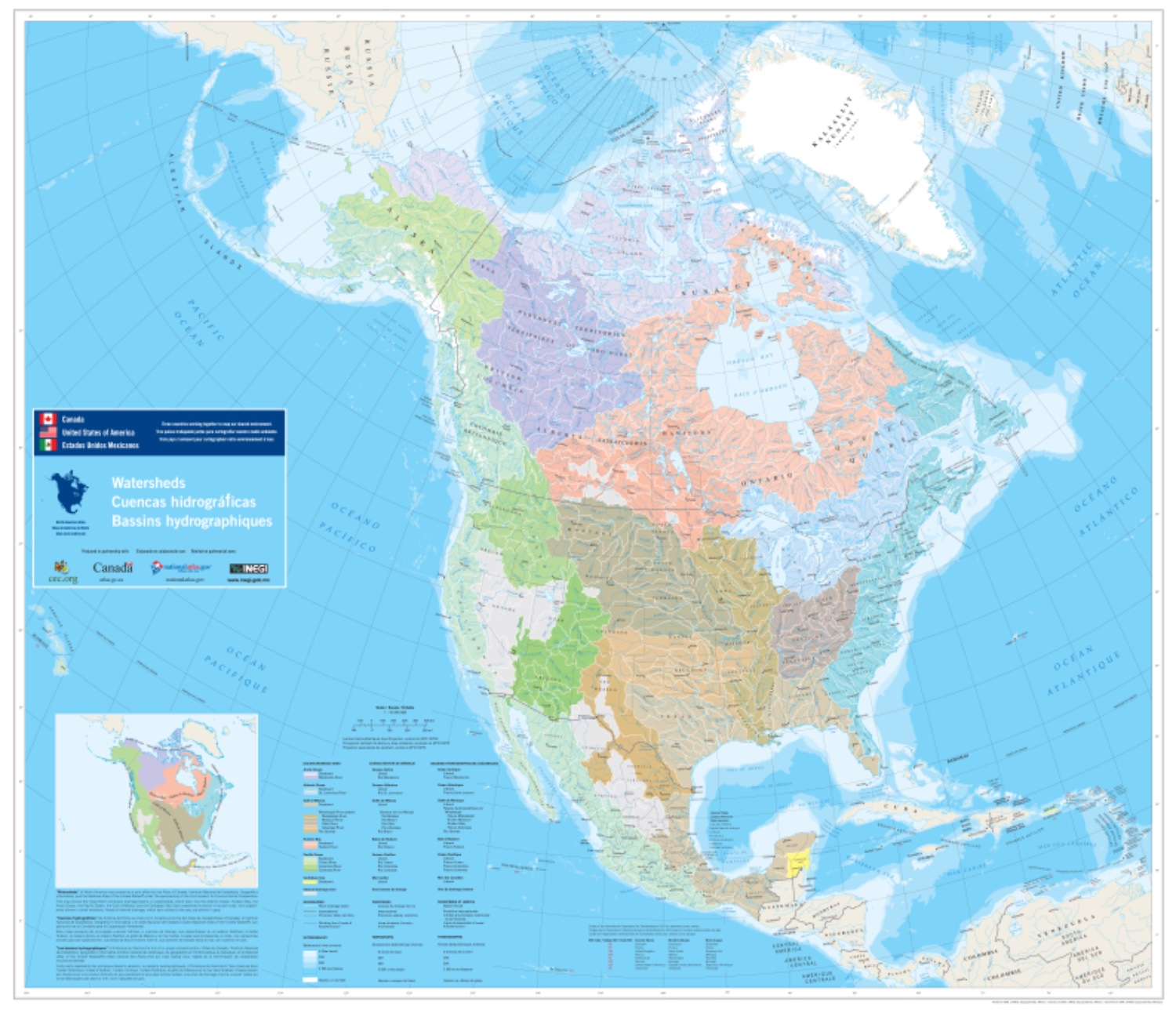
North American watersheds (6349×5469)
by
lars
2024-01-20T23:14:45Z
0
57
0
The Ottoman Empire in 1875
by
Blaze
2024-01-19T10:20:45Z
4
36
7
Sauna dress-code across Europe
by
Blaze
2024-01-18T09:56:03Z
1
116
1
Soviet-era Russian map of the San Francisco Bay Area
by
lars
2024-01-15T02:52:17Z
7
54
4
Blond–Blue Belt
by
lars
2024-01-14T01:42:53Z
2
41
0
Forests of Europe
by
Blaze
2024-01-13T17:16:07Z
2
84
1
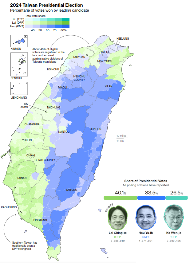
Result of today's presidential election in Taiwan.
by
garfaagel
2024-01-13T14:37:59Z
11
56
7
Largest White ancestry in every US county, based on 2020 US Census
by
Blaze
2024-01-12T00:06:31Z
5
30
2
Per capita CO2 emissions by country 2022
by
Blaze
2024-01-12T00:46:54Z
4
106
0
Second most taught foreign language in European secondary schools
by
Blaze
2024-01-10T22:21:52Z
33
67
3
Railway map of China, with colored lines showing high-speed rail. At the beginning of 2007, China had zero kilometers of high-speed rail
by
Blaze
2024-01-09T16:47:15Z
4
35
1
Mapping the world major's earthquakes from 1956 to 2022
by
Blaze
2024-01-09T16:43:22Z
4
136
7
Europe in 1789, at the start of the French revolution
by
Blaze
2024-01-09T05:57:20Z
10
40
23
Languages spoken by the leaders of Europe and North America
by
Blaze
2024-01-09T05:06:43Z
9
22
0
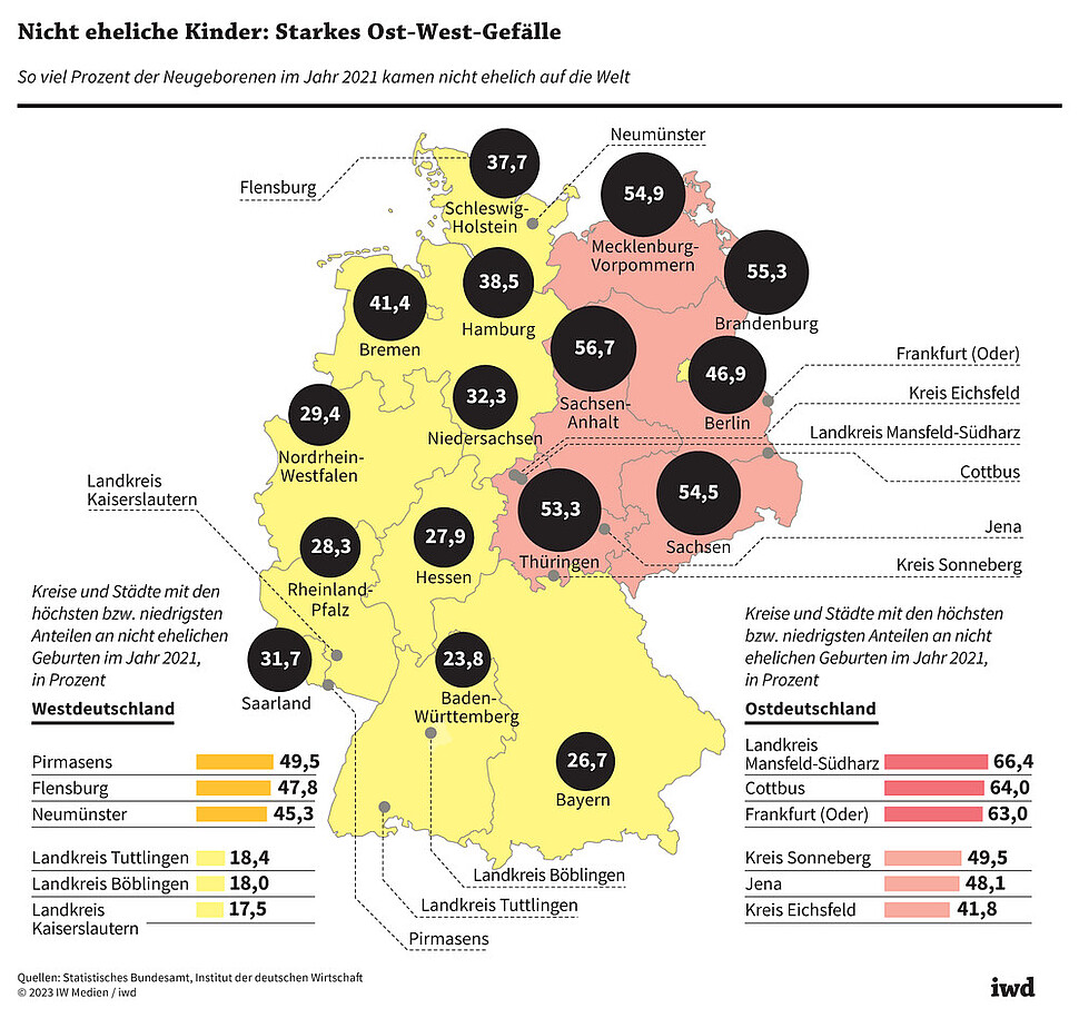
Percent of children born outside marriage in Germany, showing a clear east-west division.
by
garfaagel
2024-01-07T20:24:36Z
1
12
0
Etymological Map of Africa
by
lars
2024-01-03T00:21:31Z
0
6
0
Current and former range of tiger subspecies
by
garfaagel
2024-01-01T12:24:21Z
0
6
0
The entirety of the USSR (12 December 1991 to 16 December 1991)
by
lars
2023-12-31T14:42:25Z
0
5
0
[GIF] Reconstructed riverscape of the Danube around Wien 1500-2010
by
infeeeee
2023-12-27T12:34:02Z
0
2
0
Examining Geographic Tautologies
by
lars
2023-12-22T20:11:57Z
0
0
0
How Americans heat their homes
by
garfaagel
2023-12-20T16:47:41Z
0
1
0
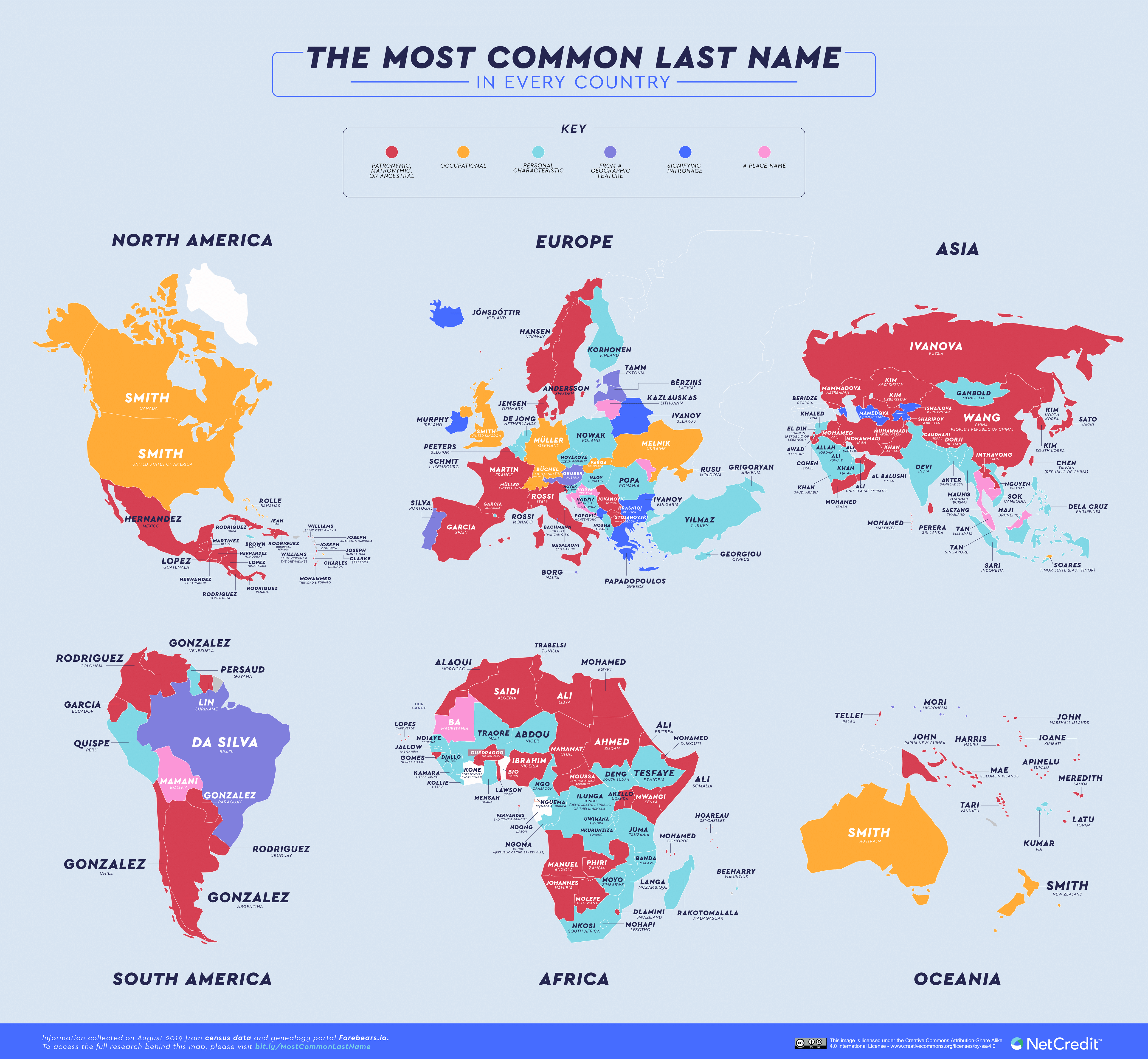
The Most Common Surname in Each Country (5000 × 4611)
by
lars
2023-12-15T13:42:31Z
0
1
0
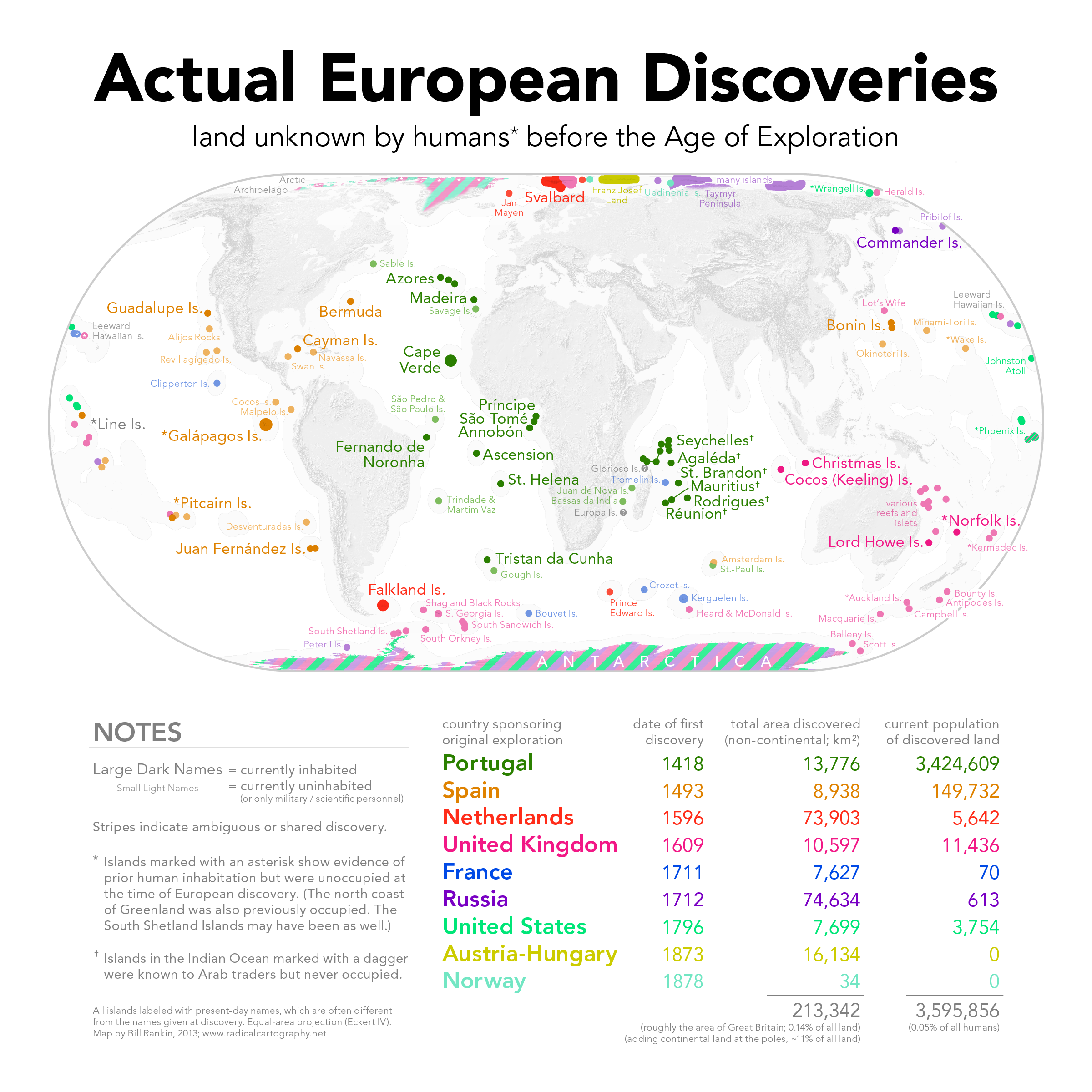
Actual European Discoveries
by
lars
2023-12-15T03:45:30Z
0
1
0
Ten of the world’s shortest borders (6283 × 5604)
by
lars
2023-12-12T22:36:36Z
0
1
0
Power socket types around the world
by
Blaze
2023-12-12T09:38:12Z
0
1
1
The US categorized by how many weather quality indicators an area has from the following: 6 hours of sunshine, winter temp over 50, summer temp under 80
by
Andrew :fediverse:
2023-12-11T19:54:35Z
1
0
0
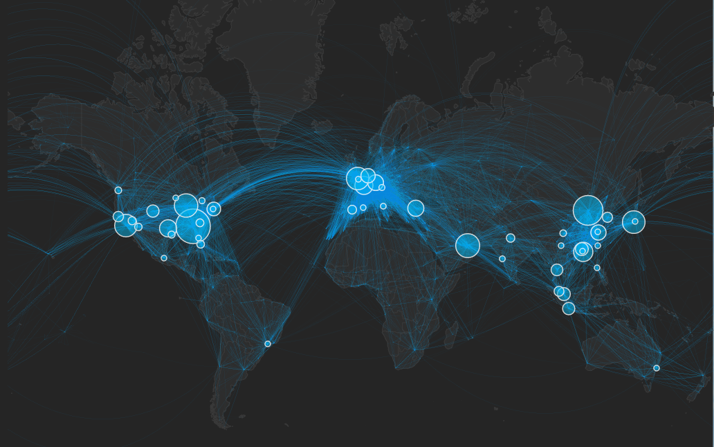
The world's 50 busiest airports (interactive map inside post).
by
garfaagel
2023-12-11T17:35:11Z
0
0
0
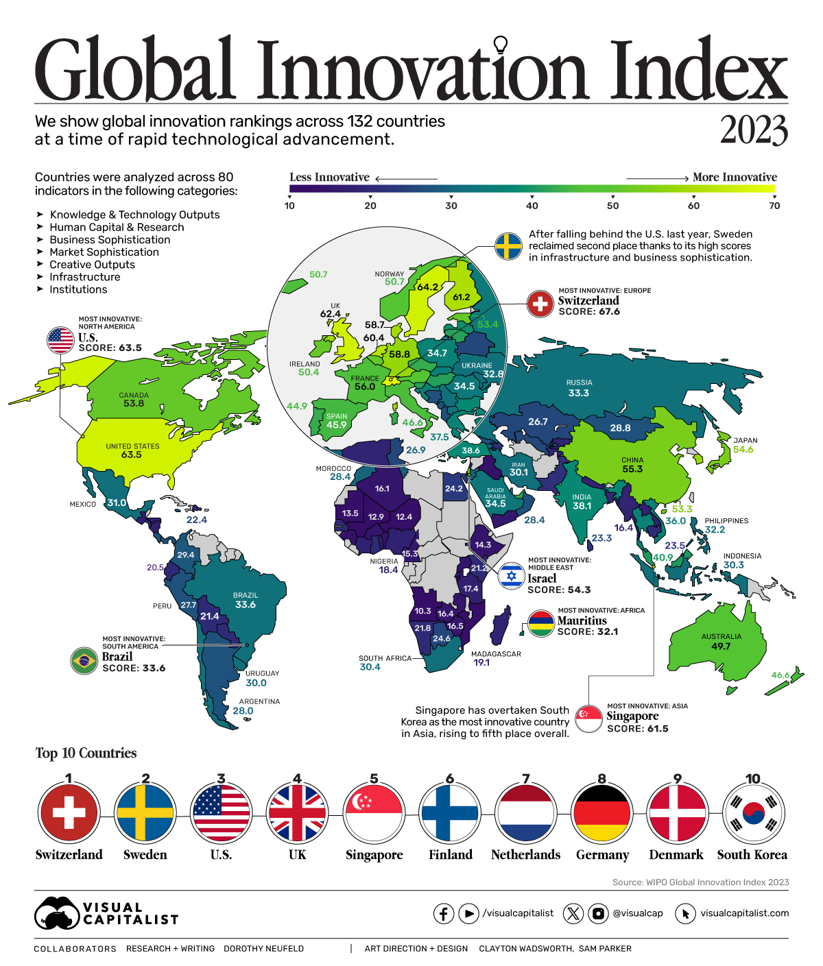
Global innovation index 2023
by
garfaagel
2023-12-06T17:22:08Z
0
1
0
Map of railways and rail gauge in Africa
by
garfaagel
2023-12-06T17:20:48Z
0
0
0
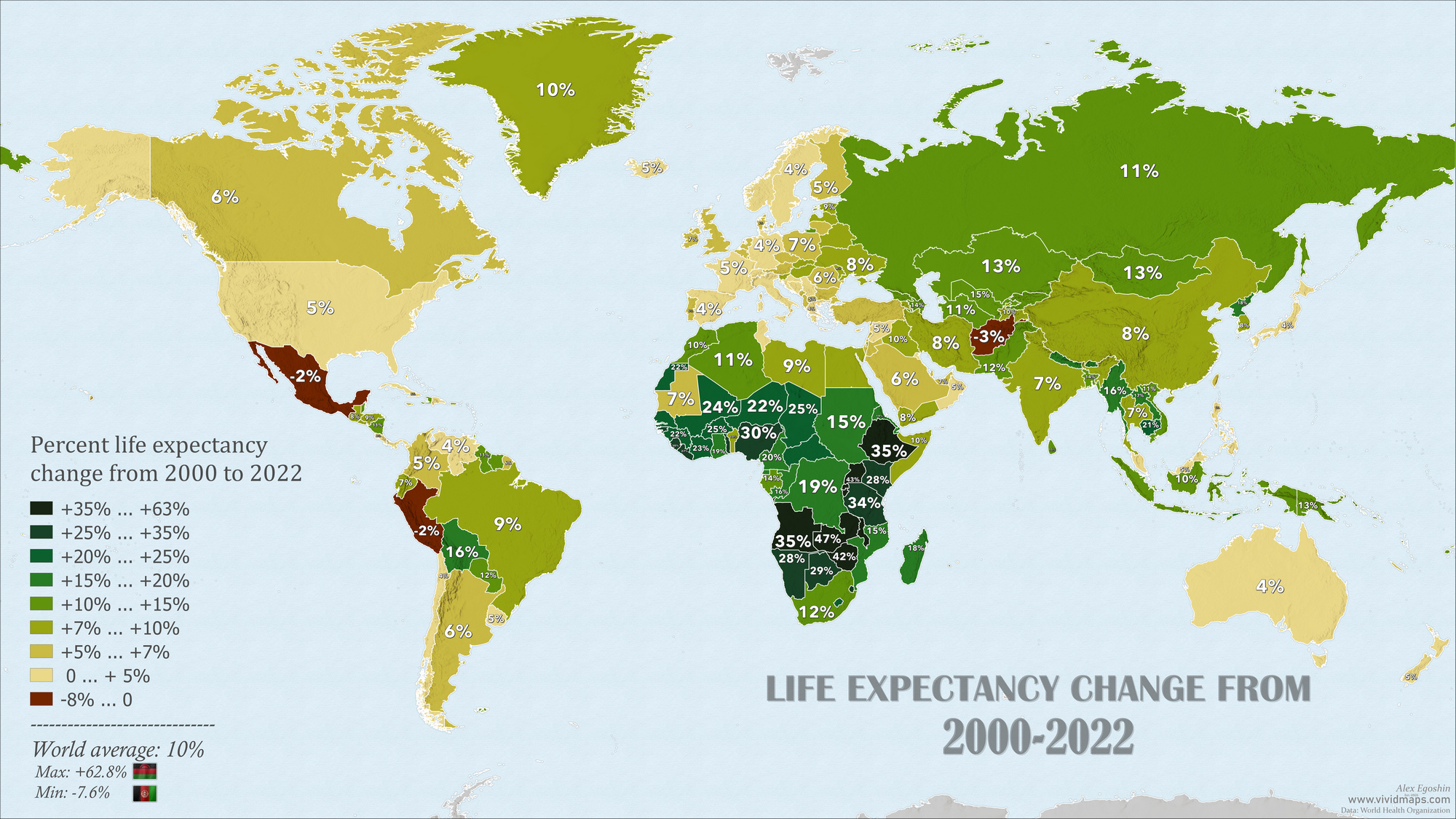
Percent life expectancy change from 2000 to 2022
by
garfaagel
2023-11-28T17:40:13Z
0
Next page
→